Today’s complex energy market and extreme weather can impact your margins in the blink of an eye. Energy suppliers require better tools to help make smarter, faster decisions.
POWWR is committed to helping suppliers maximize their position and margins through valuable resources and tools. Our regular outlook reports evaluate potential weather changes and climate effects to help better prepare your team for success.
Summer 2023 Recap
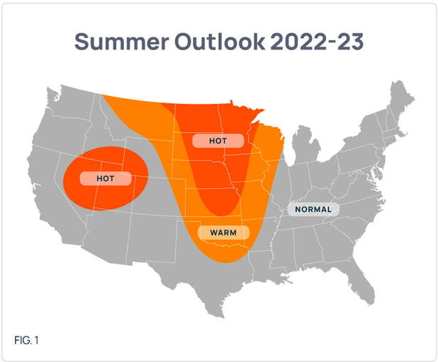
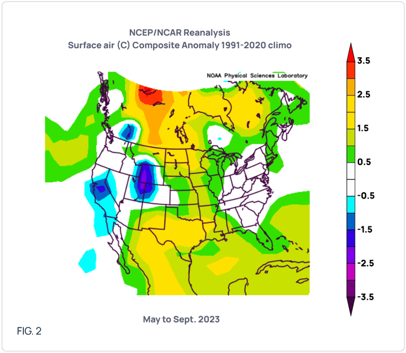
As can be seen in Figure 1, POWWR’s Summer Outlook included anomalous heat in the central US extending into Texas with the greatest anomalies in the northern Plains. Another area of anomalous warmth was forecast for the Intermountain West. We predicted ‘normal’ conditions for the East Coast into the Ohio Valley. Overall, our outlook was correct in that the Plains experienced the warmest anomalies with normal conditions for the Ohio Valley into the East Coast (Figure 2). Unfortunately, although we did indicate some warmth into Texas, we did not foresee the “bull’s eye” of warmth deep into Texas.
Winter Set-up
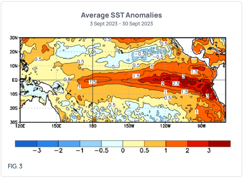
As you all probably know, El Niño conditions are building in the tropical Pacific Ocean. For our current clients, we have spoken about this on our weekly calls since late Spring. As of now, the El Niño is forecast to be at least of “moderate” intensity, with a good chance for “strong” conditions to develop. As can be seen in Figure 3, sea surface temperature (SST) anomalies have already reached the 0.5 C threshold needed to classify the El Niño. Additionally, anomalies near 2.5 C are being seen towards the central-east tropical Pacific. The extent of the warm SST anomalies westwards are causing some scientists to classify this El Niño as a “modoki” El Niño. “Modoki” is a Japanese word meaning “similar, but different” and is indicative of the fact that climate conditions may be unlike those which we see during a “typical El Niño”. I will speak to these in the section that presents the POWWR winter outlook, as the outlook is heavily influenced by the potential “modoki” nature of this El Niño.
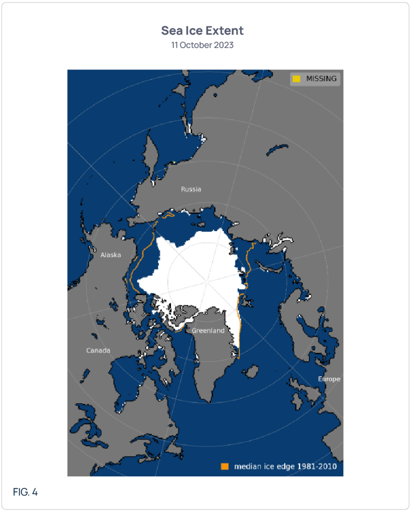
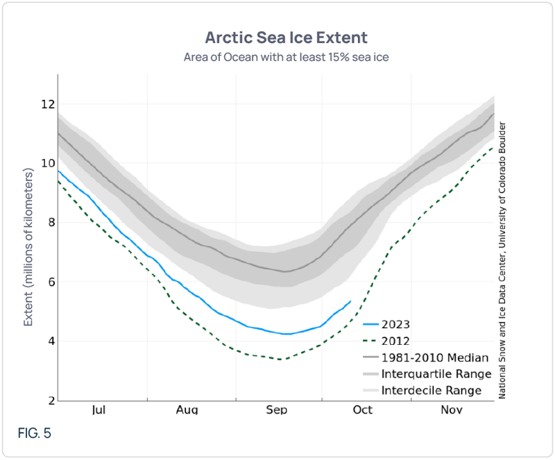
Longtime readers know that we always mention two other indicators in our winter outlooks… Arctic sea ice extent and soil moisture. The past decade (longer, actually) we have begun the Fall with the quantity and coverage of Arctic sea ice far less than average. But as we progress during the Fall and into winter, sea ice grows to an amount adequate to lead to cold anomalies in the continental US given the right jet stream set-up. This year is no different as both the areal extent and total quantity of Arctic Sea ice are far below average (Figures 4 and 5, respectively). Figure 5 also shows that the minimum quantity of Arctic sea ice was reached in September and is now in the early phases of the building process. This is the usual pattern that occurs each winter.
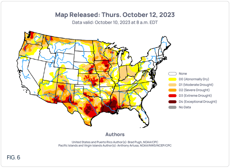
The second indicator, soil moisture, is a more short-term indice that can be swayed either direction given a series of extensive rains or the lack thereof. As of now, soil moisture is severely lacking in the Plains, from the north (and into the western Midwest) all the way south into Texas (Figure 6). When a cold air mass travels over dry soil, less energy is being used to evaporate any available moisture, so the cold air mass can stay “cold” for longer. And the opposite is true for moist soils. The cold air mass will moderate as it travels across soils with adequate soil moisture.
The POWWR 2023-24 Outlook
Given the above conditions, POWWR’s Winter Outlook is visualized in Figure 7. We foresee a generally cold NOV-MAR slant for the majority of the country, with two areas of greater cold anomalies, the southern states and the East Coast. We do expect warmer-than normal conditions for the northern tier west of the Mississippi River.
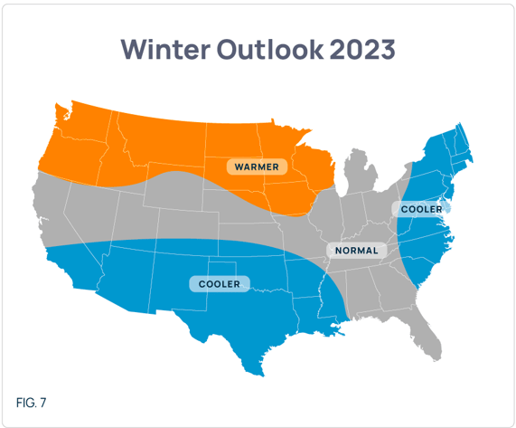
Given that the upcoming year will be marked by an El Niño, many readers are probably expecting for winter outlooks to indicate upcoming warmer conditions for the East Coast. That is where the “modoki” El Niño plays a large role. Because the warm SST pool is displaced far enough into the central Pacific Ocean, it should alter the position of the jet stream just enough to allow for troughing in the Great Lakes region, allowing for more cold air masses to filter into the east.
Timing wise, we are thinking of a relatively slow start with the coolest anomalies in NOV in the desert Southwest. DEC should bring a little more cool anomalies east of the Rockies, but still nothing too extreme. It isn’t until JAN that our analogs show extreme cold anomalies from Texas swooping upwards into the Ohio Valley and eastward into the Mid-Atlantic and New England. The analogs also show the potential for periods of cold from JAN into MAR.
As for risks to our outlook, the largest would be for warm conditions from the Midwest into New England. We do think the cold slant to ERCOT is generally solid given El Niño, regardless of the El Niño “type”.

NOTE: POWWR provides this information as a courtesy to enhance the risk management process and are not responsible for the accuracy of this forecast and/or actions taken as a result of this forecast information.
 |
|
Mr. Palao specializes in commodity risk management and the science of meteorology/climatology. He serves as one of POWWR’s many subject matter experts. He has 20 years of experience in the energy/utility industry, where he used his skills and knowledge of meteorology and advanced statistics.
From 2000 through 2011, he worked at TXU Energy Trading/Luminant Energy in Dallas where he served in three capacities. Most recently, he served as Capital/Liquidity Manager of the trading portfolio, optimizing the use of capital while still maintaining profitability. Prior to that, he managed the Weather Derivatives trading desk, devising strategies and executing trades for both speculative and hedging purposes. Upon joining TXU, he served as manager of the Quantitative Risk Group, assisting the company in the identification, quantification, and remediation of financial risks inherent in the company’s multi-commodity trading portfolio.
In his first foray into energy/utilities, he was a Marketing Executive with Louisiana Gas Service Company, a local distribution company, where he primarily marketed natural gas technology to commercial and industrial customers. Before that, he served as a Research Scientist under contract to the National Oceanic and Atmospheric Administration (NOAA).
Mr. Palao has an M.B.A. from Tulane University. He also has both an MS and BS in Meteorology from Florida State University. He is a member of the Financial Weather and Climate Risk Management Committee of the American Meteorological Society (AMS).

Share this
2022-23 Winter Outlook Report
2021-22 Winter Outlook Report